
SEVERE WEATHER: FRIDAY/SATURDAY AM
Summary
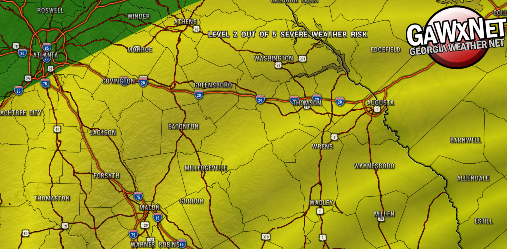
The Storm Prediction Center has placed the entire Lake Area in the Level 2 out 5 Severe Weather Risk for Friday/Saturday morning. Expect a cluster of thunderstorms to being forming Friday morning and continuing to pop up throughout Friday afternoon. […]
The Storm Prediction Center has placed the entire Lake Area in the Level 2 out 5 Severe Weather Risk for Friday/Saturday morning. Expect a cluster of thunderstorms to being forming Friday morning and continuing to pop up throughout Friday afternoon. Damaging wind, hail and a few brief spin-up tornadoes are possible with these cells throughout the day on Friday.
A line of more organized storms will form as a strong cold front makes it way closer to Georgia late Friday night and into Saturday morning. These storms are also capable of producing damaging wind, hail and more significant tornadoes.
Now is the time to prepare for these storms. Make sure you have your smart phone Wireless Emergency Alerts (WEA) turned on. A NOAA Weather Radio is an inexpensive and solid way to receive alerts 24/7. NEVER rely on outdoor tornado sirens. They often fail and even if they are operational, you will likely not hear it, especially in the middle of the night.
Tune in for live coverage as needed on the Oconee Radio Group stations: 97.7 BIG FM, Dock 103.9, Lake Country 102.3, 104.5 WMVG and 94.7 The Bulldog.